Golf challenge began as desert road game
By Denise Goolsby
The Desert Sun
A quirky, obscure sporting event is set to tee off on Saturday, continuing a high desert tradition that began in 1959.
The Pioneer Pass Golf Challenge — a day-long tournament that begins in Big Bear and ends in Yucca Valley — was originally organized to help raise funds to build a paved road between the two towns.
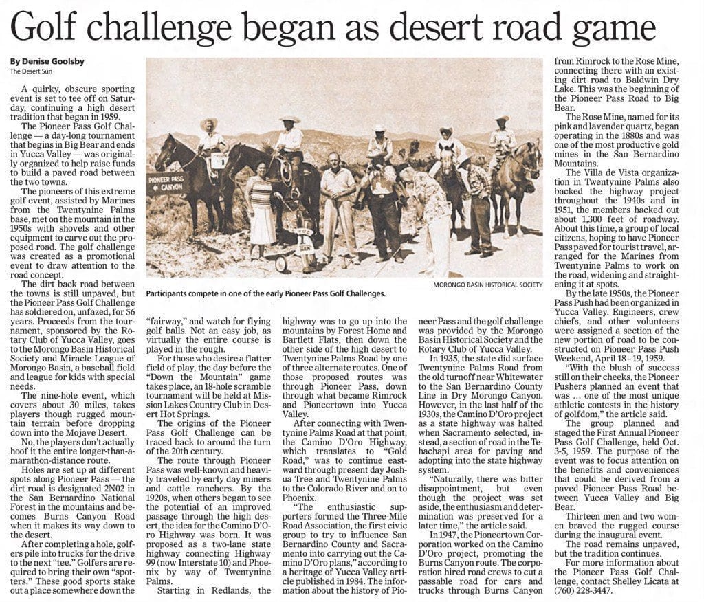
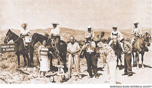
The pioneers of this extreme golf event, assisted by Marines from the Twentynine Palms base, met on the mountain in the 1950’s with shovels and other equipment to carve out the proposed concept.
The dirt back road between the towns is still unpaved, but the Pioneer Pass Golf Challenge has soldiered on, unfazed, for 56 years. Proceeds from the tournament, sponsored by the Rotary Club of Yucca Valley, goes to the Morongo Basin Historical Society and Miracle League of Morongo Basin, a baseball field and league for kids with special needs.
The nine-hole event, which covers about 30 miles, takes players through rugged mountain terrain before dropping down into the Mojave Desert
No, the players don’t actually hoof it the entire longer-than-a-marathon-distance route.
Holes are set up at different spots along Pioneer Pass — the dirt road is designated 2N02 in the San Bernadino National Forest in the mountains and becomes Burns Canyon Road when it makes its way down to the desert.
After completing a hole, golfers pile into trucks for the next drive to the next”tee.” Golfers are required to bring their own “spotters.” These good sports stake out a place somewhere down the “fairway,” and watch for flying golf balls. Not an easy job, as virtually the entire course is played in the rough.
For those who desire a flatter field of play, the day before the “Down the Mountain” game takes place, an 18-hole scramble tournament will be held at Mission Lakes Country Club in Desert Hot Springs.
The origins of the Pioneer Pass Golf Challenge can be traced back to around the turn of the century.
The route through Pioneertown Pass was well-known and heavily traveled by early day miners and cattle ranchers. By the 1920s, when others began to see the potential of an improved passage through the high desert, the idea for the Camino D’O-ro Highway connecting Highway 99 (now Interstate 10) and Phoenix by way of Twentynine Palms.
Starting in Redlands, the highway was to go up into the mountains by Forest Home and Bartlett Flats, then down the other side of the high desert to Twentynine Palms Road by one of three alternate routes. One of those proposed routes was through Pioneer Pass, down through what became Rimrock and Pioneertown into Yucca Valley.
After connecting with Twentynine Palms Road at that point, the Camino D’Oro Highway which translates to “Gold Road,” was to continue eastward through present day Joshua Tree and Twentynine Palms to the Colorado River and on to Phoenix.
“The enthusiastic supporters formed the Three-Mile Road Association, the first civic group to try to influence San Bernadino County and Sacramento into carrying out the Comino D’Oro plans,” according to a heritage of Yucca Valley article published in 1984. The information about the history of Pioneer Pass and the golf challenge was provided by the Morongo Basin Historical Society and the Rotary Club of Yucca Valley.
In 1935, the state did surface Twentynine Palms Road from the old turnoff near Whitewater to the San Bernadino County Line in Dry Morongo Canyon. However, in the last half of the 1930s, the Camino D’Oro project as a state highway was halted when Sacramento selected, instead, a section of road in the Tehachapi area for paving and adopting into the state highway system.
“Naturally, there was bitter disappointment, but even though the project was set aside, the enthusiasm and determination was preserved for a later time,” the article said.
In 1947, the Pioneertown Corporation worked on the Camino D’Oro project, promoting the Burns Canyon route. The corporation hired road crews to cut a passable road for cars and trucks through Burns Canyon from Rimrock to the Rose Mine connecting there with an existing dirt road to Baldwin Dry Lake. This was the beginning of the Pioneer Pass Road to Big Bear.
The Rose Mine, named for its pink and lavender quartz, began operating in the 1880s and was one of the most productive gold mines in the San Bernadino Mountains.
The Villa de Vista organization in Twentynine Palms also backed the highway project throughout the 1940s and in 1951, the members hacked out about 1,300 feet of roadway. About this time, a group of local citizens, hoping to have Pioneer Pass paved for tourist travel, arranged for the Marines from Twentynine Palms to work on the road, widening and straightening it at spots.
By the late 1950s, the Pioneer Pass Push had been organized in Yucca Valley, Engineers, crew chiefs, and other volunteers were assigned a section of the new portion of road to be constructed on Pioneer Pass Push Weekend, April 18 – 19, 1959.
“With the blush of success still on their cheeks, the Pioneer Pushers planned an event that was … one of the most unique athletic contests in the history of golfdom,” the article said.
The group planned and staged the First Annual Pioneer Pass Golf Challenge, held Oct. 3-5, 1959. The purpose of the event was to focus attention on the benefits and conveniences that could be derived from a paved Pioneer Pass Road between Yucca Valley and Big Bear.
Thirteen men and two women braved the rugged course during the inaugural event.
The road remains unpaved, but the tradition continues.
For more information about the Pioneer Pass Golf Challenge, contact Shelley Licata at (760) 228-3447.
Source: